Time zones and seasons have a lot of implications. You can learn a lot of big ideas about the world in a short amount of time with the connections they bring up.
Background
Why Were Time Zones Needed?
Standardizing time zones was originally motivated by the railroad system in the late 1800s. The system was now expanding to move people across great distances. It was used to help standardized listed times of arrival/departure.
This is necessary because each individual town would consider “Noon” to be when the sun reached the highest point in the sky. But, as we will see below, that is different at each location on the planet. Each stop was based on a different town’s time, making schedules confusing, something needed to be done to improve the rail system’s efficiency.
This motivation makes sense, since railroads were the first practical means for frequent travel between distant locations.
What Was the Chosen Standard?
During a meeting between many countries met to decide what should be the starting point for time zones.
The decision was Greenwich England, which was selected as the “International Standard for 0 Degrees Longitude”. The longitudinal line marking this 0 point is called the “Prime Meridian”.
- Greenwich Meridian Time is often referenced to as GMT
- This is what GMT – # means (GMT time, a # of time zones in a direction)
- Positive is East (right) of Greenwich, negative is West (left)
- GMT – 6 means 6 hours behind Greenwich’s time

Prime Meridian defines the 0 point for time zones
- The “International Date Line” is located on the opposite side of the globe from the Prime Meridian (at 180°). It separates one calendar day from another and is zigzagged to avoid cutting through countries.

Time zones and seasons are different all around the world
24 time zones were chosen, one for each hour, placed at each 15 degrees of longitude around the globe (24 * 15 = 260 degrees, a complete circle around the globe).
This means that each time zone was equally spaced out around the globe.
- This 15° increment is due to Earth’s rotation speed being about 15° every hour
- I.e. a full day, 24 hours, is a full rotation
- A meridian defines the center point of a time zone, 15 / 2= 7.5° are on either side
- Time zones in the East of Prime Meridian are “ahead in time” (relative to Prime Meridian) and thus marked with incrementing #s (positive), those West of Prime Meridian are “behind in time”
This was the original standard, however, some countries don’t follow this due to reasons such as trying to fit a country all in one time zone. For example, China has only one time zone, despite having 5 deviations of the original standard.
An interesting fact derived from this:
- China’s width is approximately 5 * 15 = 75 degrees longitude, or 15 / 360 ~= 1/5 the globe’s circumference.
Okay, that is some history behind how time zones came to be. But thinking of both time zones and seasons can help cement some of these ideas.
Here are some important points about the Earth’s rotation:
- The Earth moves and spins at the same time
- Earth rotates once every day (24 hours)
- Earth revolves around the sun once every year (365 days)
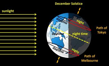
The below image shows a few important points:
- Earth is tilted (23.5°), this tilt is maintained (no wobble) as it goes around the sun
- This is important for the seasons. Northern hemisphere is
- The sun lights up only a part of the Earth at any time
- This is a representation of the “December Solstice”
- This just means a time when Earth has a maximum tilt away from the sun

Time zones and seasons are impacted by sun exposure.
By point 1: Since this tilt is maintained at all times…
- The area of the planet that gets the most direct sunlight depends on where the Earth is at in its revolution around the sun and where you are at on Earth,
- Direct vs indirect sunlight makes a large difference to the temperatures since, much like a flashlight, a direct shine will be warmer than if you tilt it slightly away.
- Indirect sunlight has the amount of heat as a direct sunlight, but it is spread out across a larger area. The result is it doesn’t feel as hot.
- Since the United States is in the Northern Hemisphere, it will receive the most sunlight when the earth is tilted towards the sun.
- The seasons are due more to the tilt of the Earth than the distance from the sun
- Earth’s revolution is roughly circular around the sun, an equal distance away.
By point 2: Due to the tilt and that the sun can only light a part of the Earth at a time…
- Some areas of the planet have a longer night (or day) than others, depending on the season. Notice how exaggerated this is near the poles.
- That is why the poles have such extreme day/night cycles throughout the year.
By point 3: Since the “December Solstice” is when the Earth’s tilt is furthest from the sun…
- For the Northern Hemisphere, this is the “Winter Solstice”
- E.g. North America
- For the Southern Hemisphere, this is the “Summer Solstice”
- E.g. Australia
So, seasons came about from the Earth’s position and its direct exposure to the sun. Time zones and seasons both play a role in the modern standards for time today.
Timezones
Big Idea: You can derive times, directions, and behaviors from the background
As an example, consider the following:
- You’re in North America.
- The continent’s map is oriented as such, with the top being the North.

Orientation of continents, impacting both time zones and seasons
Now consider the 24 time zones laid out on Earth.

Each location around the globe experiences a different time zone and season.
Notice:
- This is viewed from the top. You’re looking at the Norther Hemisphere.
- The middle marks the “North Pole”, which is where polar bears live
- Earth rotates counterclockwise when viewed with the North Pole on top.
- In other words: Earth rotates “eastward” when viewed from the side.
- “Noon” is the point where the sun is “highest in the sky” (directly overhead).
- “Midnight” is the opposite point, where sun is furthest away.
NOTE: Because of the direction of spin, you’ll see the sun first coming from the East.
- This is because the Earth rotates from left to right (from the sun’s perspective)
- So a Country more right than another Country (from the sun’s perspective) will see the sun sooner than things to the left, as the rotation occurs.
- This means the sun “rises in the East, and sets in the West”.
- This is true for any (relatively) fixed object in the sky: Moon, Planets, Stars
- You can use this to derive your directions (i.e. North/East/South/West)
Sun exposure plays an important role in both time zones and seasons. By understanding how the Earth is exposed to sun, we can understand both time zones and the seasons together.
With this in mind…
The Punchline
- If you are in the central United States, you can derive the time in California.
- Roughest Approximation:
- You’re looking at your location from a “birds-eye” view, from the perspective of the sun when it is highest in the sky.
- California is on the West Coast
- To the “left” with above perspective
- The Earth rotates counterclockwise
- “Eastward”, or from left to right with above perspective
- Since California is to your left, and the rotation is from left to right, you will see the sun ahead of California in the same day.
- Therefore: California’s time is in the past
- More Accurate:
- Consider the below image of United States with longitude lines
- Recall: Each time zone is marked in 15° increments around the globe
- NOTE: The below map has longitude lines at 10° increments
- Consider the below image of United States with longitude lines
- Roughest Approximation:

-
-
- You can see from Kansas (Central United States), to California is a little more than 2 Longitudinal lines over, or approximately 25-30°
- So, California is approximately 2 time zones over from Kansas
- Each time zone is an hour change, we are going from right to left and thus going “back” in time (to a point where the sun
-
Great, so both time zones and seasons relate to sun exposure.
Interesting Connections
Temperature Difference: North vs South Poles
Both the North and South poles are cold because they don’t get direct sunlight.
On the same token, locations around the equator (the “tropics”) are very warm due to receiving direct sunlight.
Polar Bears and Penguins
Polar bears live in the North Pole and Penguins in the South Pole, despite what fiction movies might portray (probably because they look cute together).
The North Pole is also slightly warmer than the South Pole.
I remember this by thinking “heat rises“.
Afterword
Thank you for reading!
New PROFOUND insights on a weekly basis! Subscribe to remain up to date.
Stay tuned for more clear and concise insights that aim to make sense of the universe!
What was the most interesting idea you read from this post? Share in the comments section below!
Learn more about the author here!
Check us out on Facebook!
Check out our Store for the latest E-Books, Services, How-To Guides, and other goodies!
I am always looking to improve my reach and the impact that I have with my writing, please provide your feedback in the comments below.
Share with those who need this and enter in your email on the right side-bar to Join the MaxedOut Community and receive our latest insights that can improve your life.
New deep, understandable, and thorough content weekly!
Featured Image is by PIRO4D on pixabay
Created By: Brandon
This is such an informational post, thank you for sharing all this information and the reasons behind it all 😊
You're welcome! Thank you for your visit and feedback (: I love relating big ideas together to make sense of seemingly confusing information. Informational content like this, if presented right, can serve as an anology for many important ideas, such as learning and insights into how the brain and universe work. Hopefully inspiring deeper thinking in others 🤔 Have a wonderful day!
Definitely deeper thinking helps others 😊
This is so informative! I never knew I needed to know this, but I’m glad I do 🙃 You learn something new everyday!
Thank you (: The content is more of an analogy for the fact that everything is connected and that learning is best approached from a holistic standpoint. Knowing the fundamentals of something is akin to teaching someone how to fish, you can make better decisions on a wider range of topics. Like being able to derive time and seasonal information by understanding the location of the sun relative to Earth and what that means. But, the content is fascinating, nonetheless :D
So much interesting information. I’m bookmarking this for a detailed read later.Thank you for writing this!
Thank you, Abhishek. I see you're a programmer as well! I like the variety of content on your site. I haven't ventured to posts about tech just yet, so far, this has been my most "technical" post. I'll be keeping my eyes on your work to see how you balance your variety in topics. So far, I like the website structure, it makes a big difference! Well done. Thank you for your visit 😊